
Portal:New Jersey/Selected article
Selected article 1
Portal:New Jersey/Selected article/1
Local and national reaction to the attacks involved a wave of panic that led to shark hunts aimed at eradicating the population of "man-eating" sharks and protecting the economies of New Jersey's seaside communities. Resort towns enclosed their public beaches with steel nets to protect swimmers. Scientific knowledge about sharks before 1916 was based on conjecture and speculation. The attacks forced ichthyologists to reassess common beliefs about the abilities of sharks and the nature of shark attacks.
Selected article 2
Portal:New Jersey/Selected article/2
The company was founded by Thomas Rogers in an 1832 partnership with Morris Ketchum and Jasper Grosvenor as Rogers, Ketchum and Grosvenor. Rogers remained president until his death in 1856 when his son, Jacob S. Rogers, took the position and reorganized the company as Rogers Locomotive and Machine Works. The younger Rogers led the company until he retired in 1893. Robert S. Hughes then became president and reorganized the company as Rogers Locomotive Company, which he led until his death in 1900.
Rogers avoided the American Locomotive Company (ALCO) merger in 1901 through closing and reopening as Rogers Locomotive Works. The company remained independent until 1905, when ALCO purchased it; ALCO continued building new steam locomotives at the Rogers plant until 1913. ALCO used the Rogers facilities through the 1920s as a parts storage facility and warehouse, but eventually sold the property to private investors. Today, several Rogers-built locomotives exist in railroad museums around the world, and the plant's erecting shop is preserved as the Thomas Rogers Building; it is the current location of the Paterson Museum, whose mission is to preserve and display Paterson's industrial history.
Selected article 3
Portal:New Jersey/Selected article/3

During World War II, the New Jersey shelled targets on Guam and Okinawa, and screened aircraft carriers conducting raids in the Marshall islands. During the Korean War she was involved in raids up and down the North Korean coast, after which she was decommissioned in to the United States Navy reserve fleets, better known as the "mothball fleet". She was briefly reactivated in 1968 and sent to Vietnam to support U.S. troops before returning to the mothball fleet in 1969. Reactivated once more in the 1980s as part of the 600-ship Navy program, New Jersey was modernized to carry missiles and recommissioned for service. In 1983, she participated in U.S. operations during the Lebanese Civil War.
Selected article 4
Portal:New Jersey/Selected article/4

Selected article 5
Portal:New Jersey/Selected article/5

Trucks are prohibited from the Pulaski Skyway for the "safety and welfare of the public", due to its outdated design. They must use an alternate route known as U.S. Route 1/9 Truck, a series of local roads through Jersey City, Kearny and Newark that carried traffic before the Skyway was built. Pedestrians and bicycles are also banned, as the road is a freeway with no sidewalks.
Selected article 6
Portal:New Jersey/Selected article/6

Selected article 7
Portal:New Jersey/Selected article/7

Selected article 8
Portal:New Jersey/Selected article/8
The Port Authority operates the Port Newark–Elizabeth Marine Terminal, which handled the third largest amount of shipping of all ports in the United States in 2004 and the largest on the Eastern Seaboard. The Port Authority also operates Hudson River crossings, including the Holland Tunnel, Lincoln Tunnel, and George Washington Bridge connecting New Jersey with Manhattan, and three crossings that connect New Jersey with Staten Island.
Selected article 9
Portal:New Jersey/Selected article/9

In Princeton itself, General John Sullivan forced some British troops who had taken refuge in Nassau Hall to surrender, ending the battle. After the battle, Washington moved his army to Morristown, and with their third defeat in 10 days, the British evacuated southern New Jersey. With the victory at Princeton, morale rose in the ranks and more men began to enlist in the army. The battle was the last major action of Washington's winter New Jersey campaign, and the site is now Princeton Battlefield State Park.
Selected article 10
Portal:New Jersey/Selected article/10

Interstate 95 was originally supposed to continue northeast from the routes' junction near Trenton on the proposed Somerset Freeway, but this plan was cancelled, limiting I-295's capability as a true bypass between Baltimore and New York City. Today, traffic on Interstate 295 is directed to take Interstate 195 (or surface street connections further south) to the New Jersey Turnpike to reach New York City. The same route is prescribed for traffic on I-95 in Pennsylvania and near Trenton to bridge the gap with I-95 further north.
Selected article 11
Portal:New Jersey/Selected article/11

The Atlantic City Expressway has an open system of tolling, with two mainline toll plazas (Egg Harbor in Hamilton Township and Pleasantville) and seven exits with ramp tolls. The total cost to travel the length of the Atlantic City Expressway is currently $3.75 and E-ZPass is accepted. In 2008, two separate plans were made to raise the tolls along the road, one proposed by Governor Jon Corzine and one proposed by the South Jersey Transportation Authority that would increase tolls 50%. The latter toll increase took place effective November 18, 2008. The expressway features one service area, Farley Plaza, in Hamilton Township a short distance west of the Egg Harbor Toll Plaza, as well as a gas station and mini-mart near the Atlantic City Welcome Center in Pleasantville. In a few years, the road is expected to use all-electronic tolling.
Plans for the road go back to the 1930s, when a parkway was proposed between Camden and Atlantic City that was never built. Plans resurfaced for the road in the 1950s when a group of officials led by State Senator Frank S. Farley pushed for a road to help the area economy. The New Jersey Expressway Authority was created in 1962 to be responsible for building an expressway. The Atlantic City Expressway was built between 1962 and 1965 at a total cost of $39.8 million. The South Jersey Transportation Authority assumed control of the road in 1991 from the New Jersey Expressway Authority.
Selected article 12
Portal:New Jersey/Selected article/12
The state constitution reinforces the basic rights found in the United States Constitution, but also contains several unique provisions, such as regulations governing the operation of casinos. At 26,159 words, the document is slightly shorter than the average American state constitution (about 28,300 words).
Selected article 13
Portal:New Jersey/Selected article/13

First landing unopposed on Staten Island on July 3, 1776, Howe assembled an army composed of elements that had been withdrawn from Boston in March following their failure to hold that city, combined with additional British troops, as well as Hessian troops rented from several German principalities. Washington had New England soldiers as well as regiments from states as far south as Virginia. Landing on Long Island in August, again without opposition, Howe drove Washington him north to White Plains, New York. At that point Howe returned to Manhattan to capture forces Washington had left in the north of that island.
Washington and much of his army crossed the Hudson River into New Jersey, and retreated all the way across the Delaware River into Pennsylvania, shrinking due to ending enlistment periods, desertions, and poor morale. Howe ordered his troops into winter quarters in December, establishing a chain of outposts from New York to Burlington, New Jersey. Washington, in a tremendous boost to American morale, launched a successful strike against the Trenton garrison after crossing the icy Delaware River, prompting Howe to withdraw his chain of outposts back to New Brunswick and the coast near New York, while Washington established his winter camp at Morristown. During the remaining winter months, both sides skirmished frequently as the British sought forage and provisions.
Britain maintained control of New York City and some of the surrounding territory until the war ended in 1783, using it as a base for operations elsewhere in North America. In 1777, General Howe launched a campaign to capture Philadelphia, leaving General Sir Henry Clinton in command of the New York area, while General John Burgoyne led an attempt to gain control of the Hudson River valley from Quebec that failed at Saratoga. Northern New Jersey was the scene of skirmishing between the opposing forces for the rest of the war.
Selected article 14
Portal:New Jersey/Selected article/14

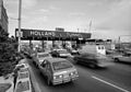
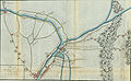
While the U.S. Route 1/9 Truck designation was first used in 1953, the roadway comprising the route was originally designated as an extension of pre-1927 Route 1 in 1922, a route that in its full length stretched from Trenton to Jersey City. U.S. Route 1/9 was designated along the road in 1926 and one year later, in 1927, this portion of pre-1927 Route 1 was replaced with Route 25 as well as with a portion of Route 1 north of the Communipaw Avenue intersection. Following the opening of the Pulaski Skyway in 1932, U.S. Route 1/9 and Route 25 were realigned to the new skyway. After trucks were banned from the skyway in 1934, the portion of Route 25 between Newark and Route 1 was designated as Route 25T. In 1953, U.S. Route 1/9 Truck was designated in favor of Route 25T and Route 1 along this segment of road. The portion of the truck route north of Route 7 is being rebuilt as part of a $271.9 million project that will replace the viaduct over St. Paul's Avenue. Construction, which started in late 2008, is expected to be complete in late 2012.
Selected article 15
Portal:New Jersey/Selected article/15

The shutdown officially concluded after the legislature adopted a budget on July 8. All government services were restored by 8:30 a.m. on July 10, 2006.
Selected article 16
Portal:New Jersey/Selected article/16
Late on the evening of April 12, 1777, four thousand British and Hessian troops under the command of Lieutenant General Charles Cornwallis marched from the British stronghold of New Brunswick. All but one detachment reached positions surrounding the outpost before the battle began near daybreak the next morning. During the battle, most of the 500-man garrison escaped by the unblocked route. American reinforcements arrived in the afternoon, but not before the British plundered the outpost and began the return march to New Brunswick.
Selected article 17
Portal:New Jersey/Selected article/17

While the American force of 600 was eventually forced from their positions by the larger British force, the action prevented Donop from being in his assigned base at Bordentown, New Jersey and in a position to assist Johan Rall's brigade in Trenton, New Jersey when it was attacked and defeated by George Washington after his troops crossed the Delaware on the night of December 25–26.
Selected article 18
Portal:New Jersey/Selected article/18

This action was one of a series of skirmishes known as the Forage War that persisted in northern New Jersey through the first few months of 1777, and it demonstrated that militia companies were capable of putting up a significant fight.
Selected article 19
Portal:New Jersey/Selected article/19

In mid-June General Howe marched most of his army into central New Jersey in an attempt to lure George Washington's Continental Army to a place where it might be better attacked than its defensive position in the Watchung Mountains. When Washington refused to abandon his position Howe returned to Amboy on June 22. Washington's forward divisions, including that of Lord Stirling, shadowed this British movement, and Washington moved his main army out of the hills. Howe seized this opportunity, and on June 26 marched two columns of troops out in an attempt to cut Washington off from the high ground. These troops skirmished with Lord Stirling's troops, and eventually engaged in a pitched battle in Scotch Plains. Stirling's outnumbered force retreated, but Washington, alerted to the British movement, had by then retreated back into the hills.
Selected article 20
Portal:New Jersey/Selected article/20

Lieutenant General Charles Cornwallis led the British forces southward in the aftermath of the December 26 battle. Leaving 1,400 men under Lieutenant Colonel Charles Mawhood in Princeton, Cornwallis advanced on Trenton with about 5,000 men on January 2. His advance was significantly slowed due to defensive skirmishing by American riflemen under the command of Edward Hand, and the advance guard did not reach Trenton until twilight. After assaulting the American positions three times, and being repulsed each time, Cornwallis decided to wait and finish the battle the next day. Washington moved his army around Cornwallis's camp that night and attacked Mawhood at Princeton the next day. That defeat prompted the British to withdraw from most of New Jersey for the winter.
Selected article 21
Portal:New Jersey/Selected article/21

The Continental Army had previously suffered several defeats in New York and had been forced to retreat through New Jersey to Pennsylvania. Morale in the army was low; to end the year on a positive note, George Washington—Commander-in-Chief of the Continental Army—devised a plan to cross the Delaware River on the night of December 25–26 and surround the Hessian garrison the next morning.
Because the river was icy and the weather severe, the crossing proved dangerous. Two detachments were unable to cross the river, leaving Washington and the 2,400 men under his command alone in the assault. The army marched 9 miles (14 km) south to Trenton. The Hessians had lowered their guard, thinking they were safe from the American army, and did not post a dawn sentry. Washington's forces caught them off guard and, before the Hessians could resist, they were taken prisoner. Almost two thirds of the 1,500-man garrison was captured, and only a few troops escaped across Assunpink Creek.
Despite the battle's small numbers, the American victory inspired rebels in the colonies. With the success of the revolution in doubt a week earlier, the army had seemed on the verge of collapse. The dramatic victory inspired soldiers to serve longer and attracted new recruits to the ranks.
Selected article 22
Portal:New Jersey/Selected article/22

The British troops wanted to have fresh provisions to consume, and also required fresh forage for their draft animals and horses. General George Washington ordered the systematic removal of such supplies from areas easily accessible to the British, and companies of American militia and troops harassed British and German forays to acquire such provisions. While many of these operations were small, in some cases they became quite elaborate, involving more than 1,000 troops. The American operations were so successful that British casualties in New Jersey (including those of the battles at Trenton and Princeton) exceeded those of the entire campaign for New York.
Selected article 23
Portal:New Jersey/Selected article/23

The courthouse was used as the primary seat of government for Hudson County from its opening on September 20, 1910 until the construction of the Hudson County Administration Building in 1966. The courthouse was vacant for many years and was scheduled for demolition. The building was added to the National Register of Historic Places on August 25, 1970. Restoration began in the mid-1970s, and the building was reopened in 1985. In 1984, the Hudson County Board of Chosen Freeholders renamed the building in honor of Supreme Court Justice William J. Brennan Jr. The restoration of the courthouse was acknowledged by a Victorian Society in America Preservation Award in 1988.
As of 2011, the courthouse has seven working courtrooms and also houses the offices of the County Executive and the Hudson County Bar Association; in the past it has been used in a number of television programs and movies, including scenes in the television series Law & Order, and for commercials.
Selected article 24
Portal:New Jersey/Selected article/24

Two portions of I-295 predate the Interstate Highway System, the Delaware Memorial Bridge, built in 1951, and the portion concurrent with US 130, built in two sections that opened in 1948 and 1954. The route was designated on these sections in 1958. The portion of I-295 connecting to I-95 in Delaware opened in 1963 while most of the route in New Jersey was finished by the 1980s. The last portion of I-295 to be completed, near the interchange with I-195 and Route 29, was completed in 1994. Interstate 95 was originally supposed to continue northeast from the routes' junction near Trenton on the proposed Somerset Freeway, but this plan was canceled, limiting I-295's capability as a true bypass between Baltimore and New York City. Today, traffic on Interstate 295 is directed to take Interstate 195 (or surface street connections further south) to the New Jersey Turnpike to reach New York City. The same route is prescribed for traffic on I-95 in Pennsylvania and near Trenton to bridge the gap with I-95 further north. I-295 previously extended a few miles past the US 1 interchange to where it would have met the Somerset Freeway; in 1993, the portion past US 1 became part of I-95. As a result of the Pennsylvania Turnpike/Interstate 95 Interchange Project in Bristol Township, Pennsylvania, I-295 was originally planned to continue past its northern terminus along I-95, crossing into Pennsylvania and heading south to the interchange. Instead, it was decided that I-195 would be extended into Pennsylvania, moving the northern terminus of I-295 to the I-195 interchange south of Trenton.
Selected article 25
Portal:New Jersey/Selected article/25

After World War II, freeway approaches were planned for both sides of the Ben Franklin Bridge, which was completed in 1926 and served as a part of US 30. In Pennsylvania, the Vine Street Expressway was planned to run along the northern edge of Center City Philadelphia to the Schuylkill River, while in New Jersey, the North-South Freeway was to head south along the Route 42 corridor. When the Interstate Highway System was created in the 1950s, this stretch of highway was a part of I-80S, with Interstate 680 continuing on the Schuylkill Expressway to the Walt Whitman Bridge. In 1964, the designations became I-76 and I-676, respectively, and in the 1970s the two routes were switched onto their current alignments. I-676 in New Jersey was completed between I-76 and Morgan Boulevard by 1960 and north of there to downtown Camden by the 1980s. The Vine Street Expressway was opened from the Schuylkill Expressway to 18th Street by 1960 and east of there to the Ben Franklin Bridge on January 10, 1991 after several obstacles to construction.
Selected article 26
Portal:New Jersey/Selected article/26

Prior to 1927, the route was designated as Route 17N, which was to run from Newark to the New York state line. This route had followed various local streets, including the Franklin Turnpike north of Hackensack. In 1927, Route 17N became Route 2, which was designated along the portion of Route 17N between Route 7 in North Arlington to the New York border near Suffern, New York. This route was moved to a multilane divided highway alignment north of Rutherford by 1937. Route 2 became Route 17 in 1942 to match the designation of New York State Route 17 for defense purposes during World War II. The entire Route 17 corridor was once planned to be a freeway until the 1960s and later plans to extend the route south of Route 3 to Interstate 280 in 1972 and to the New Jersey Turnpike in 1987 both failed. Over the years, the portion of Route 17 north of Route 3 has seen many improvements, including the widening of much of the road to six lanes and the removal of most at-grade intersections in the 1950s as well as more recent improvements to the interchanges with Route 4 in Paramus in 1999 and Essex Street on the Lodi/Maywood border in 2008. The route is currently undergoing improvements between Route 3 and U.S. Route 46 and is expected to see improvements from Williams Avenue in Hasbrouck Heights to south of Route 4 in Paramus.
Selected article 27
Portal:New Jersey/Selected article/27

The first portion of the present-day Route 495, at the entrance to the Lincoln Tunnel, was constructed in 1937 when the Lincoln Tunnel opened. In 1939, it was extended west to Route 3 and it became an eastern extension of that route. In 1952, the portion of the route west of Route 3 was opened when the New Jersey Turnpike was completed. In 1958, the road was incorporated into the Interstate Highway System and was designated as part of Interstate 495. Since the Mid-Manhattan Expressway that would have connected the route to New York's Interstate 495 (Long Island Expressway) was canceled, Interstate 495 officially became New Jersey Route 495 in 1979 with signs being changed in 1989.
Selected article 28
Portal:New Jersey/Selected article/28

Seton Hall is made up of eight different schools and colleges with an undergraduate enrollment of about 5,200 students and a graduate enrollment of about 4,400. Its School of Law, which is ranked by US News & World Report as one of the top 100 law schools in the nation, has an enrollment of about 1,200 students. For 2009, BusinessWeek's "Colleges with the Biggest Returns" ranked Seton Hall among the top 50 universities in the nation that open doors to the highest salaries. Seton Hall's Stillman School of Business is ranked 56 out of the top 100 undergraduate business schools and #1 in the state of New Jersey according to BusinessWeek.
The Seton Hall College of Medicine and Dentistry was the first school of medicine in the State of New Jersey. The school was acquired by the state in 1965, and is now the New Jersey Medical School, part of the University of Medicine and Dentistry of New Jersey.
Selected article 29
Portal:New Jersey/Selected article/29

Teaneck was created on February 19, 1895 by an Act of the New Jersey Legislature. Teaneck was formed from portions of Englewood Township and Ridgefield Township, both of which are now defunct (despite existing municipalities with similar names), along with portions of Bogota and Leonia. Independence followed the result of a referendum held on January 14, 1895, in which voters favored incorporation by a 46–7 margin. To assuage the concerns of Englewood Township's leaders, the new municipality was formed as a township, rather than succumbing to the borough craze sweeping across Bergen County at the time. On May 3, 1921, and June 1, 1926, portions of what had been Teaneck were transferred to Overpeck Township.
Teaneck lies at the crossroads of Interstate 95 and the eastern terminus of Interstate 80. It is bisected north and south by Route 4 and east and west by the CSX Transportation West Shore Line. Commercial development is concentrated in four main shopping areas, on Cedar Lane, Teaneck Road, DeGraw Avenue, West Englewood Ave. and Queen Anne Road, more commonly known as "The Plaza".
Teaneck's location at the crossroads of river, road, train and other geographical features has made it a site of many momentous events across the centuries. After the American defeat at the Battle of Fort Washington, George Washington and the troops of the Continental Army retreated across New Jersey from the British Army, traveling through Teaneck and crossing the Hackensack River at New Bridge Landing, which has since been turned into a state park and historic site commemorating the events of 1776 and of early colonial life. In 1965, Teaneck became the first community in the nation with a white majority to voluntarily desegregate its public schools, after the Board of Education approved the plan by a 7–2 vote on May 13, 1964. Teaneck has a diverse population, with large Jewish and African American communities, and growing numbers of Hispanic and Asian residents.
Selected article 30
Portal:New Jersey/Selected article/30
The current alignment of US 1/9 south of Elizabeth was planned as pre-1927 Route 1 in 1916; this road was extended to the Holland Tunnel in Jersey City in 1922. When the U.S. Highway System was created in 1926, US 1 and US 9 were marked concurrent through northern New Jersey between Rahway on the current alignments of Route 27 and US 1/9 Truck. In 1927, pre-1927 Route 1 became Route 25, and Route 1 and Route 6 were legislated along the current US 1/9 north of Jersey City. US 1/9 originally went to the Holland Tunnel on Route 25; after the George Washington Bridge opened the two routes were realigned to their current routing north of Jersey City. After the Pulaski Skyway opened in 1932, US 1/9 and Route 25 were routed to use this road, which soon had a truck ban resulting in the creation of Route 25T (now US 1/9 Truck). South of Newark, US 1/9 was moved from Route 27 to Route 25. In 1953, the state highways running concurrent with US 1/9 in New Jersey were removed. In 1964, the approaches to the George Washington Bridge were upgraded into I-95.
Selected article 31
Portal:New Jersey/Selected article/31

Most of US 30 in New Jersey follows the White Horse Pike, a turnpike chartered in 1854 to run from Camden to Stratford and eventually toward Atlantic City. In 1917, pre-1927 Route 3 was legislated to run from Camden to Absecon on the White Horse Pike, while US 30 was designated in New Jersey in 1926 to connect Camden and Atlantic City via the White Horse Pike. A year later, pre-1927 Route 3 was replaced by Route 43, which ran between US 130 near Camden and US 9 (now Route 157) in Absecon, and Route 25 was designated along the portion of US 30 between the Ben Franklin Bridge and US 130. The segment of US 30 past Route 43 into Atlantic City became Route 56 in 1938. In 1953, the state highway designations were removed from US 30. A freeway was proposed for US 30 in Camden County during the late 1960s, running from Camden to Berlin; however, it was never built.
Selected article 32
Portal:New Jersey/Selected article/32
Washington's army then crossed the river a third time at the end of the year, under conditions made more difficult by the uncertain thickness of the ice on the river. They defeated British reinforcements under Lord Cornwallis on January 2, 1777, and defeated his rear guard at Princeton on January 3, before retreating to winter quarters in Morristown, New Jersey.
Selected article 33
Portal:New Jersey/Selected article/33

The aircraft were in an area known as the "Hudson River VFR Corridor", which extends from the surface of the river to altitudes of 800 to 1,500 feet (240 to 460 m) at various locations along the Hudson River in the immediate area of New York City. Within this corridor, aircraft operate under visual flight rules, under which the responsibility to see and avoid other air traffic rests with the individual pilots rather than with the air traffic controller.
Because of the heavy commercial air traffic into Newark, LaGuardia, and Kennedy airports, small aircraft are restricted from much of the airspace around the city. Many airplanes that need to transit the New York metro area use the VFR corridor as an alternative to going east of the city (over water) or west (toward Pennsylvania). The corridor is also heavily used by helicopter tour companies, which take passengers on sight-seeing tours of the New York skyline. Visual flight rules on the river corridors by Manhattan have been subject to considerable debate since the 2006 New York City plane crash, in which New York Yankees pitcher Cory Lidle crashed into an apartment building while flying using visual flight rules on the East River. This was the first aircraft collision over the Hudson River since 1976.
The collision, which occurred opposite Manhattan's 14th Street, was about 40 blocks south of where US Airways Flight 1549 ditched in the Hudson River on January 15, 2009, with no loss of life, after the plane suffered a complete loss of thrust following a bird strike.
Selected article 34
Portal:New Jersey/Selected article/34
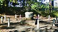
After British forces captured New York City in the first part of the New York and New Jersey campaign, they established outposts throughout central New Jersey. Geary, the son of Admiral Sir Francis Geary, was operating from a station at Pennington when he was killed in the ambush. His body was concealed and later buried in a shallow grave, preventing its recovery by British troops. In the 19th century local historical interest led to the confirmation of his grave's location, and the establishment of markers at the site and in England.
Making a casualty of Geary was one of a number of militia actions that resulted in a reduced scope of British reconnaissance, contributing to the eventual success of George Washington's crossing of the Delaware River and victory at the Battle of Trenton.
Selected article 35
Portal:New Jersey/Selected article/35

The station house was built in 1869 (and opened on September 9, 1869) by the Hackensack and New York Railroad on a track extension from Passaic Street in Hackensack. The station was turned over to the Erie Railroad in 1896 and New Jersey Transit in 1983. The next year, the station was listed on the National Register of Historic Places. The station building, which was 139 years old, was destroyed in a three-alarm fire and explosion at 5:55 a.m. on January 10, 2009. At the time the station house was the second-oldest (active service) in New Jersey (second to Ramsey's Main Street station). The station building was also the site for the Green Caboose Thrift Shop, a charity gift shop maintained by a branch of the Hackensack University Medical Center from 1962 until the station depot burned in 2009.
Selected article 36
Portal:New Jersey/Selected article/36

The genus is solely known from the New Jersey amber deposits along the Atlantic coastal plain in New Jersey, United States, which date from the Turonian stage (about 90–94 Mya) of the Upper Cretaceous. Archaeomarasmius is one of only five known agaric fungus species known in the fossil record, and the only one to be described from New Jersey amber.
Selected article 37
Portal:New Jersey/Selected article/37
The Atlantic City – Brigantine Connector was initially planned in 1995 to provide a direct connection between the Atlantic City Expressway and the Brigantine area. Construction of the road was completed in 2001 at a total cost of $330 million (equivalent to $568 million in 2024). Before the Atlantic City – Brigantine Connector was planned, Mirage Resorts president Steve Wynn acquired a piece of land near the northern end of the proposed connector and planned for a direct exit ramp to a proposed casino called Le Jardin. Donald Trump, the chief executive officer of Trump Organization, who owned the nearby Trump Marina (now Golden Nugget), took legal action against the state for the proposed ramp to Wynn’s casino. Despite the legal concerns, construction on the connector began in 1998. Wynn’s proposed casino was canceled following the acquisition of Mirage Resorts by MGM Grand Inc., which, as the MGM Mirage company, proposed the Borgata casino. Meanwhile, Trump’s casino received a direct ramp from the connector.
Selected article 38
Portal:New Jersey/Selected article/38

Selected article 39
Portal:New Jersey/Selected article/39

Carlton Hill Station opened in 1888 on Jackson Avenue and namesake Erie Avenue in Rutherford. The station was served by the main line until 1963, when the Passaic Plan was undertaken, removing tracks at Passaic Park, Passaic, Clifton, and Lake View stations. At that point, the nearby drawbridge was permanently swung open and later removed, leaving a branch to Carlton Hill. For the next few years, Carlton Hill received deadhead trains and a rare Carlton Hill – Rutherford – Hoboken Terminal train schedule. In 1966, when several underused branches, including the Carlton Hill, lost service, the old main line alignment to Carlton Hill was abandoned. The tracks remain, though the building is gone.
Selected article 40
Portal:New Jersey/Selected article/40
Selected article 41
Portal:New Jersey/Selected article/41

Selected article 42
Portal:New Jersey/Selected article/42

The main event saw Samoa Joe defeat Booker T, who was accompanied by Sharmell, in a steel structure with six sides that was filled with weapons—a match titled a Six Sides of Steel Weapons match—to retain the TNA World Heavyweight Championship. A.J. Styles defeated Kurt Angle in the second main match on the card in which the wrestler who was unable to respond to a ten count by the referee would lose. Two tag team matches were featured bouts scheduled on the undercard. In the first, Christian Cage and Rhino defeated Team 3D (Brother Ray and Brother Devon) in a New Jersey Street Fight in which no one could be disqualified. The second was for the TNA World Tag Team Championship, in which Beer Money, Inc. (Robert Roode and James Storm) defeated the champions, The Latin American Xchange (Homicide and Hernandez), to win the championship.
The event marked the beginning of a return angle for Jeff Jarrett, who had not been active in the company since May 2007, when Samoa Joe used the signature weapon of Jarrett's (an acoustic guitar) in his match with Booker T. When the event was released on DVD, it reached a peak position of number five on Billboard's DVD Sales Chart. Wrestling Observer.com and 411Mania.com writer Larry Csonka rated the entire event a 7.6 out of 10 stars, higher than the 2007 event's rating of 4.
Selected article 43
Portal:New Jersey/Selected article/43

Selected article 44
Portal:New Jersey/Selected article/44
Eventually, the upper level roadway was designated by the New Jersey State Highway Department as Route 25AD. A spur of the recently designated State Highway Route 25A, the highway department made the roadway a suffixed spur of the highway because of the close proximity. Route 25A later became New Jersey Route 58 and is now an alignment of Interstate 280. The designation remained intact until the 1953 New Jersey state highway renumbering on January 1, 1953, when it was changed to New Jersey Route 158. Route 158 appeared on the state map for New Jersey until up to 1960, when it disappeared from the maps as a public highway. After 1960, Route 158 did not appear on maps, and the bridge was torn down around 1979.
Selected article 45
Portal:New Jersey/Selected article/45

Route 64 was designated originally as an alignment of Route 31A, a spur off of State Highway Route 31 (currently U.S. Route 206) from Princeton eastward to Hightstown, where it met State Highway Route 33. The state planned on turning the alignment into a full-fledged expressway for several decades, including constructing the alignment that Route 64 currently uses in 1939. The route was amended in 1941, and was renumbered from Route 31A to Route 64 in the 1953 renumbering. Route 64 was proposed to become part of the Princeton–Hightstown Bypass (later designated New Jersey Route 92), but completion never occurred. Currently, the route remains the bridge over the Northeast Corridor. However, it is not currently planned that Route 64 will receive an extension of sorts from the proposed Penns Neck Bypass to U.S. Route 1, a proposed realignment of County routes 526 and 571.
Selected article 46
Portal:New Jersey/Selected article/46

The main event was a Last Ride match, where the objective was to place an opponent in a hearse located on the entrance stage and drive them out of the arena. WWE Champion John "Bradshaw" Layfield (JBL) defeated The Undertaker in this match to retain his title. Two predominant bouts were featured on the undercard; in respective singles matches, John Cena defeated Booker T to win the WWE United States Championship, and The Big Show defeated Kurt Angle.
No Mercy grossed over $700,000 ticket sales from an attendance of 10,000, and received 240,000 pay-per-view buys. This event helped WWE increase its pay-per-view revenue by $6.2 compared to the previous year. The professional wrestling section of the Canadian Online Explorer website rated the entire event a 5 out 10 stars, describing the event as, "an absolutely terrible" pay-per-view event.
Selected article 47
Portal:New Jersey/Selected article/47
The route is named for the New Jersey Palisades, a line of cliffs rising along the western side of the Hudson River. In New Jersey, the parkway is designated, but not signed as, Route 445. A short spur in Fort Lee is designated, but not signed as, Route 445S. In New York, the roadway is designated New York State Route 987C (NY 987C), an unsigned reference route. As with most parkways in the New York metropolitan area, commercial traffic is prohibited from using the PIP. The Palisades Interstate Parkway was built from 1947–1958, and fully opened to traffic on August 28, 1958.
Selected article 48
Portal:New Jersey/Selected article/48

Selected article 49
Portal:New Jersey/Selected article/49
The Sopranos is an American television drama series created by David Chase that revolves around the New Jersey-based Italian-American mobster Tony Soprano (James Gandolfini) and the difficulties he faces as he tries to balance the often conflicting requirements of his home life and the criminal organization he heads. The series also features Tony's family members and Mafia associates in prominent roles and storylines, most notably his wife Carmela (Edie Falco) and cousin and protégé Christopher Moltisanti (Michael Imperioli). The many conflicts in his life lead to an on-off professional relationship with psychiatrist Dr. Jennifer Melfi (Lorraine Bracco).
The series premiered on the premium cable network HBO in the United States on January 10, 1999 and ended its original run of six seasons and 86 episodes on June 10, 2007. The show has also been broadcast on A&E in the United States and internationally. The Sopranos was produced by HBO, Chase Films and Brad Grey Television. It was primarily filmed at Silvercup Studios, New York City and on location in New Jersey. The executive producers throughout the show's run were Chase, Brad Grey, Robin Green, Mitchell Burgess, Ilene S. Landress, Terence Winter, and Matthew Weiner. Chase also served as showrunner and head writer.
A major commercial and critical success, The Sopranos is the most financially successful series in the history of cable television and is acknowledged as one of the greatest television series of all time and a seminal work of fiction. The series is noted for its high level of quality in every aspect of production and is particularly recognized for its writing, its cinematic style, and the performances of its lead actors. The show is credited with bringing a greater level of artistry to the television medium and paving the way for many successful drama series that followed. It also won a multitude of awards, including twenty-one Emmys and five Golden Globes.
A staple of 2000s American popular culture, The Sopranos has been the subject of much parody, controversy, and analysis, and has spawned books, a video game, high-charting soundtrack albums, and a large amount of assorted merchandise. Several members of the show's cast and crew that were previously largely unknown to the public have had successful careers after The Sopranos.
Selected article 50
Portal:New Jersey/Selected article/50

In July 2017, the municipalities of Mahwah, Upper Saddle River, and Montvale in Bergen County, New Jersey, in the United States, opposed extension of an eruv within their borders. An eruv is a land area surrounded by a boundary of religious significance, often marked by small plastic pipes (called lechis) attached to utility poles. The demarcation permits Orthodox Jews to push or carry objects (such as prayer books, keys, or baby strollers) within the eruv on the Jewish Sabbath that otherwise is considered forbidden under Orthodox Jewish law.
The three municipalities ordered that the borders of the eruv be dismantled having been erected without the appropriate consents. Many Mahwah residents protested against the prospect of Orthodox Jews from Rockland County, New York using local parks or seeking to buy homes there.
After no agreement could be reached, the eruv association brought suit against each of the municipalities. Mahwah's actions in passing a township ordinance to bar nonresidents of New Jersey from its parks, and the hostility of some residents and council members towards those who supported the eruv led Democratic candidate for Governor of New Jersey Phil Murphy and others to make accusations of antisemitism. The presiding judge in the lawsuits, John Michael Vazquez, in January 2018 made it clear he felt the municipalities did not have a strong case and urged them to settle. The three municipalities settled with the eruv association, allowing the eruv borders to remain. Mahwah settled a lawsuit from the New Jersey Attorney General accusing it of discrimination. (Full article...)
Selected article 51
Portal:New Jersey/Selected article/51 The COVID-19 pandemic reached the U.S. state of New Jersey with the first confirmed case occurring in Bergen County on March 2, 2020, and testing positive on March 4. , 1.63 million cases were confirmed in the state, incurring 26,795 deaths.
On March 9, 2020, Governor Phil Murphy declared a state of emergency. A day later, schools and universities across the state began closing and switching classes to online instruction. Also on March 10, the first person in the state died from the disease. (Full article...)
Selected article 52
Portal:New Jersey/Selected article/52
.jpg)
The Glen Rock is a 570-ton boulder located in Glen Rock, New Jersey, United States. The boulder, which is the namesake of the town in which it is located, is the largest glacial erratic found atop Triassic bedrock in the state of New Jersey. The exact origin of the rock is uncertain, though studies alternatively place its origin in New York State's Hudson Highlands and the New Jersey Highlands. The Glen Rock, which is composed of gneiss, is located in the center of a former glacial lake.
The cultural history of the Glen Rock predates the settlement of New Jersey by European colonists. The Lenape, who referred to the boulder as Pamackapuka, used the rock as a trail marker, a location to build signal fires, and as a throne for chiefs used when presiding over meetings. Later, beginning in colonial times, European settlers to the region used the rock as a landmark on trails and as a marker for land deeds. The Glen Rock, which had been largely submerged under soil, was excavated during road work in 1912; supporting structures were added to the rock during that time to prevent it from collapsing. Following the First World War, a memorial plaque was installed on the rock to honor veterans who had died during the conflict. In 1964, the New Jersey State Office of Historic Sites designated the Glen Rock as a state landmark. (Full article...)