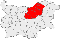
Severen Tsentralen Planejamento Região - Severen Tsentralen Planning Region
Coordenadas : 43 ° 15'N 26 ° 0'E / 43,250 26,000 ° N ° E
|
Severen Tsentralen Planejamento Região
Северен централен район за планиране
| |
|---|---|
 | |
| País |
|
| Assento | estratagema |
| Área | |
| • total | 14,974.0 km 2 (5,781.5 sq mi) |
| População (2016)
| |
| • total | 815441 |
| • Densidade | 54 / km 2 (140 / sq mi) |
| Fuso horário | UTC + 2 ( EET ) |
| • Verão ( DST ) | UTC + 3 ( EET ) |
| NUTS código | BG32 |
| PIB per capita (PPS) | 9500 (2015) |
| HDI (2015) | 0,775 alta · 3ª |
Severen Tsentralen Planejamento Região ( Bulgarian : Северен централен район за планиране ) é uma região de planejamento da Bulgária , que abrange cinco províncias da Bulgária: Ruse , Veliko Tarnovo , Gabrovo , Targovishte e Razgrad .
A região é maioritariamente habitado por búlgaros , turcos e ciganos pessoas. Suas maiores cidades são Ruse (população de 175.000), Gabrovo (67.000) e Veliko Tarnovo (100.000, incluindo interior).
Severen Tsentralen é uma das regiões menos desenvolvidas da Europa. Sua principal centro econômico é Ruse , o maior porto fluvial da Bulgária.
